|
Theories of Suess
In the late 1800s there were two features of Earth that led to the development of the theory of plate tectonics. The
geologist Eduard Suess tried to solve how mountain ranges form. He said that during the cooling of earth from a molten state
caused the more dense materials to sink toward the center, and the less dense materials to float and form the crust. From
this he speculated that mountain ranges were formed from the contraction and cooling of Earth. He then went on to try and
explain the origins of the oceans, continents, and the similarities of fossils found on separate continents. He made a model
where, during the cooling process, parts of Earth could sink deeper than others, forming ocean basins. He said that parts
of the sea floor along with continents could rise and sink as the Earth cooled. This led him to propose the idea of
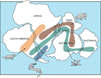
land bridges between continents. He invented the term Gondwanaland to describe a continent made up of cantral and southern
Africa, Madaascar, and peninsular India. All of these locations had similar fossils that were hundreds of millions of years
old. Suess said that these land bridges allowed for animals to go to different areas without crossing the ocean.
Pangea
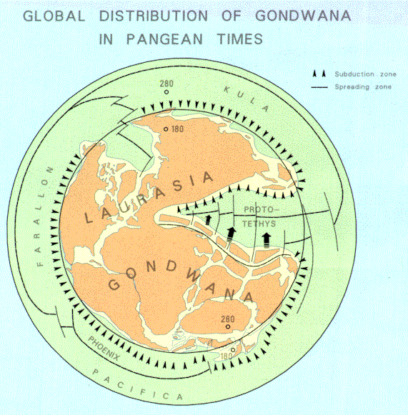
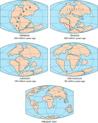
Wegener stated that 200 million years ago there was a super continent known as Pangea, the Greek word for land. He said
that this continent then went on to break into separate continents that then moved apart. He said that compression at the
leading edge of a moving continent was the cause of the formation of mountains.These hypothesis allowed Wegener to explain
the varying ages of different mountain belts. He said that the timing of the breakup was a factor, with some parts separating
earlier than others. his evidence included similar rocks and fossils found on separate continents, and allowed for the sense
of the continents fitting together like a puzzle.
Reconstructing
225 million years ago is only a small fraction of Earth's history. There might be rocks around you that are older. The
positions of the continents before 225 million years ago can also be reconstructed using the same type of evidence for reconstructing
Pangea, only it is extremely more difficult. The oldest oceanic crust geologists have discovered is only 200 million years
old. Therefore evidence for the earlier positions must be obtained from the continents themselves. Old mountain belts help
in the location of ancient collision zones. Fossils and rock types also provide evidence for locations of ancient seas, glaciers,
mountains, and ecological regions. Continents like Pangea are known as super continents, and geoscientists believe that there
was one one before Pangea. The cycle of the breakup and reassembly of continents is known as the Wilson Cycle.
|
 |
|
|
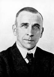
Theories of Wegener
The German geoscientist, Alfred Wegener, proposed the idea of continental drift in 1912. He said there was many problems
with the contraction theory. one of these problems was the compression of the Alps. The rock layers in the Alps extremely
folded and stacked on top of each other, showing a horizontal shortening of the original distances. Wegener did not believe
that contraction could cause such shortening. He also theorized that contraction should form uniform wrinklies in the Earth,
not these narrow zones of folding. Radioactive heat's discovery provided evidence against cooling. The heat caused by radioactive
decay would work against the process of cooling and contracting.
Accepting Wegener's Theories
Reactions to Wegener's ideas were mixed. Some accepted his evidence, while others argued that there was no way
continents could "plow through" the ocean floor. Many geoscientists rejected his theories. In 1926 there was an international
meeting held, devoted to discussion of continental drift.Wegener's evidence for the drift was strong, but the mechanism he
proposed for it was weak. People finally started to become convinced of continental drift by World War II. The sea floor
was explored, and then mapped extensively. By the 1960s the theory of plate tectonics had been developed. There is so much
evidence to support plate tectonics, that most geoscientists accept the theory today.
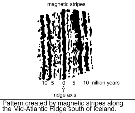
Paleomagnetism
Geoscientists collect rocks containing magnetite, and measure the past magnetism. This past magnetism is known as paleomagnetism.
They put a sample in a special room arranged so that Earth's present magnetic field is canceled out. The magnetic field of
Earth has the same pattern that would be observed as if it were a giant bar magnet inside Earth. It is believed that Earth's
magnetic field is caused by the movements of liquid iron in Earth's core. The angle that the magnetic field lines make with
Earth's surface changes from the equator to the poles. The lines are nearly horizontal near the equator, and almost vertical
near the poles. Paleomagnetism of a rock can tell you the latitude of a rock called the paleolatitude. Measurement of the
paleolatitude is one thing geoscientists use to reconstruct past super continents. But there is no way to measure paleolongitude,
because magnetic filed lines are always north-south.
|
|
|
|
|
How the Continents Move
Wegener thought that the material beneath the Litosphere acted like a slow-moving fluid. Other geologists thought that
folded mountains were evidence of contraction, but Wegener thought they were evidence of horizontal compression caused by
continents moving. These folded mountains convinced Wegener that the inner forces of Earth were powerful enough to move continents.
A quote from Wegener explains how all the geological evidence allowed "fit together"; " It is just as if we were to refit
the torn pieces of a newspaper by matching their edges and then check whether the lines of print run smoothly across. If they
do, there is nothing left to conclude but that the pieces were in fact joined this way. if only one line was available to
the test, we would still have found a high probability for the accuracy of the fit, but if we have n number of lines, this
probability is raised to the nth power."
Using Evidence
Today evidence such as; magnetic striping on the ocean floor, ages of the ocean-floor basalts, outlines of continental
plates, and the locations of similar fossils and rocks have allowed scientists to reconstruct the breakup of Pangea. It began
to breakup 200 million years ago as continental rifts began to open, and oceanic crust was formed. Pangea continued to pulled
apart, and oceanic crust was formed between the northern and southern continents. New ocean floor formed between Antarctica
and Australia and between Africa and South America. And India separated from Antarctica and traveled north.
|
|
|
|
|